


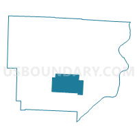
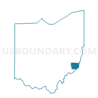
PRECINCT PERRY, Monroe County, Ohio
About
Outline

Summary
| Unique Area Identifier | 650111 |
| Name | PRECINCT PERRY |
| County | Monroe County |
| State | Ohio |
| Area (square miles) | 24.36 |
| Land Area (square miles) | 24.36 |
| Water Area (square miles) | 0.01 |
| % of Land Area | 99.96 |
| % of Water Area | 0.04 |
| Latitude of the Internal Point | 39.65078000 |
| Longtitude of the Internal Point | -81.07473230 |
Maps

Graphs
Select a template below for downloading or customizing gragh for PRECINCT PERRY, Monroe County, Ohio


Neighbors
Neighoring Voting District (by Name) Neighboring Voting District on the Map
- PRECINCT BENTON, Monroe County, OH
- PRECINCT CENTER SOUTH, Monroe County, OH
- PRECINCT GREEN, Monroe County, OH
- PRECINCT JACKSON, Monroe County, OH
- PRECINCT WASHINGTON, Monroe County, OH
- PRECINCT WAYNE, Monroe County, OH
Top 10 Neighboring County Subdivision (by Population) Neighboring County Subdivision on the Map
- Center township, Monroe County, OH (3,647)
- Washington township, Monroe County, OH (511)
- Jackson township, Monroe County, OH (477)
- Perry township, Monroe County, OH (451)
- Green township, Monroe County, OH (447)
- Wayne township, Monroe County, OH (362)
- Benton township, Monroe County, OH (338)